PHOTOS: According to Geolocation, Azerbaijanis Have Entered 2 km into Armenian Territory near Verin Shorja
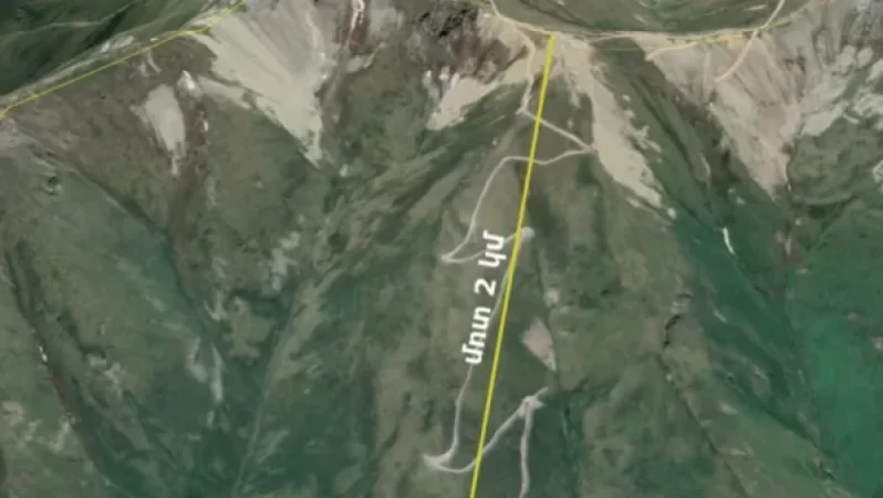
On May 14, a video was published showing Azerbaijani soldiers approximately 6 km west of the village of Verin Shorja in the Gegharkunik region. Experts from Razm.info have geolocated the area and determined that the Azerbaijani side has advanced approximately 2 km directly into Armenian territory.
As previously mentioned, the filming was conducted in an area located about 6 km west of Verin Shorja, on the slope of a mountain. The border between the Azerbaijani-occupied Karvachar and the Gegharkunik region of Armenia runs along mountain peaks, but as is visible from the video, Azerbaijani soldiers are standing on the slope and have moved forward approximately 2 km in a straight line.
We present the geolocation image below.
[c3d9f60a729532531574a9721b31250f.png]
[326b8f36efb59223200f818cf9dc4c2d.png]
Նմանատիպ հոդվածներ

What was the acting Minister of Defense doing at a restaurant on Northern Avenue? The Ministry of Defense clarifies
Information has circulated on the internet indicating that the Minister of Defense of Armenia is currently at a restaura...

Pashinyan Officially Appeals to CSTO: Official Statement
The official website of the Prime Minister of the Republic of Armenia has issued a statement indicating that Acting Prim...
Negotiations Yielded No Results Today: Goris Deputy Mayor Reports Combat Rotation in Syunik
The negotiations concluded today without results and are set to continue tomorrow. This was stated by Menua Hovsepyan, t...

What is the situation in the Armenian community of Israel? Patriarchate representative provides details to Sputnik
There are no Armenians among the victims and casualties of the rocket fire in the city of Lod, Israel. This information...
Ավելին Society բաժնից

August 7 Could Become a Day of Dangerous Turn: Robert Amsterdam on the Catholicos Trial

8-Year-Old Monte and Syune Conquer Mount Ararat

Changes to Bus Routes in Yerevan on August 7 and 8